Scientists sense tech revolution
A small but powerful new tool is helping environmental scientists create 3D maps of hard-to-access parts of the Northern Territory, to inform research on carbon dynamics, fire regimes and small mammal ecology.
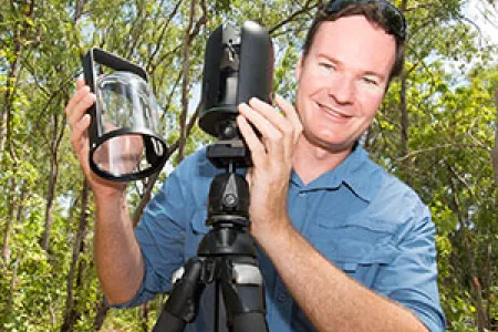
The compact 1kg Leica BLK360 laser scanner will allow Charles Darwin University researchers to measure vegetation structure and volume at field sites that are only accessible on foot, including mangroves and dense or rocky scrubland.
Associate Professor of Remote Sensing Shaun Levick, who is working on savanna carbon and fire management projects at CDU and CSIRO, said the device would assist research into how different fire management regimes impact habitat diversity.
“This new data stream is part of the Big Data revolution taking place in ecology,” he said.
“The new scanner will help us understand the types of habitats birds and mammals need to survive, which will feed into studies exploring how habitat diversity relates to animal conservation.”
Dr Levick said this would include a study by CDU researchers Dr Brett Murphy and Hugh Davies on cat predation of small mammals on the Tiwi Islands, north of Darwin.
He said the ultra-portable device, which has a range of 60m, would complement its larger and heavier counterpart, which scoped distances of up to 2km from field sites with vehicle access.
“We took the new scanner for a trial in Darwin’s mangroves, in collaboration with EcoScience NT,” he said.
“We were walking in mud up to our knees to take various scans, which we merged to make a 3D model of the area – a car would not have been able to drive in there.
“The results are promising and the images are georeferenced, so in future we can go to the same place; repeat scans will provide information on growth rate and mangrove rehabilitation success.”
The $23,000 scanner, purchased by CDU’s Research Institute for the Environment and Livelihoods after being released on the market earlier this year, is also used in engineering, architecture and forensics.
Dr Levick said students would use the laser scanner in CDU’s Remote Sensing classes from 2018.
