News
New fire-edge maps helping to understand how landscapes stop fires
A land’s topography and landscape features have an influence on how fires behave, which is why local knowledge is vital in fire management.
But in Northern Australia’s savanna country many fires start, spread and exhaust themselves without a witness.
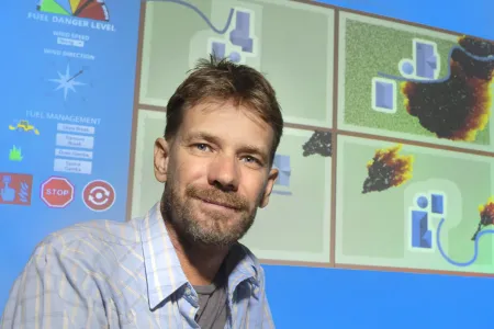
So, a Charles Darwin University (CDU) fire research team has put 22 years of burnt area data into a web map interface that studies fire edges, to identify features that might help explain what stops fire.
“The savanna country of Northern Australia burns regularly so we can start seeing patterns,” fire expert Rohan Fisher said.
Dr Fisher, from the Northern Institute, announced the project at the Indigenous Carbon industry Network’s 2023 North Australia Savanna Fire Forum being hosted at CDU’s Casuarina campus this week.
More than 350 savanna fire experts and rangers from around the world were in the audience when the web-based, fire management tool was launched.
“When fire managers are trying to keep carbon captured in the landscape and protect biodiversity, they need to get their hands on good fire information that is clearly presented,” Dr Fisher said.
“Understanding where fires spread can help with fire management planning, seeing where fires have stopped historically in the web interface also helps communicate fire plans to others.”
But Dr Fisher said that trying to extinguish fast moving savanna fires posed risks, which the maps could help us understand.
“Savanna fire management in northern Australia has been a huge success with over 50% of the north experiencing less fire now than a few years ago.
“Despite this, northern fire managers are constantly working to improve these outcomes and constantly rely on these types of research data to refine their mitigation and firefighting work,” he said.
The mapping of the fire edges would have not been possible without the data collected for over two decades through the North Australia & Rangelands Fire Information (NAFI) service.
The service is celebrating its 20th year of tracking fires through satellite imagery across Northern Australia.
“NAFI has really underpinned the revolution in fire management across the north through supporting and combining local and indigenous knowledge with satellite derived fire information,” Dr Fisher said
“NAFI was, and remains, the only fire information tool focused on fire as a land management issue, with an emphasis on supporting land managers.”
See the fire edge maps at Landscape Knowledge.
Related Articles

Australia ranked among world's top countries for quality of life
Australia is one of the world's best countries for overall quality of life, according to an international study into what truly drives well-being.
Read more about Australia ranked among world's top countries for quality of life
CDU invests $2m in First Nations research scholarships
In a push to engage more First Nations students, Charles Darwin University (CDU) is investing up to $2 million in Higher Degree by Research (HDR) scholarship initiatives to strengthen pathways, participation and success for First Nations researchers.
Read more about CDU invests $2m in First Nations research scholarships
CDU student becomes first City of Sydney international student ambassador
For the first time a Charles Darwin University (CDU) student has been accepted into the award-winning City of Sydney International student leadership and ambassador (ISLA) program.
Read more about CDU student becomes first City of Sydney international student ambassador


