News article
Weather radars reign for info on flying animals
Scientists are using weather radars, originally developed to measure rainfall, to study the flight patterns of birds, bats and insects. A researcher claims, however, that we should use radars to measure flying animals more often.
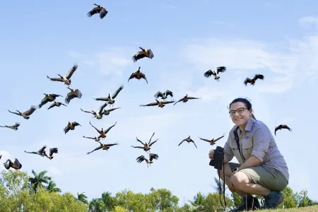
Charles Darwin University PhD candidate Rebecca Rogers said weather radars could provide information about the number of animals in the air, the height of their flight path, and the speed and direction of their flight.
“We can use this information with other techniques such as GPS tracking devices and aerial survey data to paint a bigger picture about flying animals’ migration and distribution patterns,” Rebecca said.
Rebecca is researching how we can use these radars to study long-term changes in movement behaviours of magpie geese, a water bird common in Northern Australia. Magpie geese are increasingly spotted in urban areas and have become a costly problem for mango farmers during harvest season.
Most of the published ecological studies using these radars occur in the Northern Hemisphere; in the Southern Hemisphere, however, this technology is currently under-utilised.
“We want to focus on how we can use weather radar to better manage flying animals,” Rebecca said.
“Magpie geese are a good model species because we already have good survey data on where they are during certain times of the year; we can add our radar data on top of that. They also have a synchronised pattern of movement and are large bodied, which makes it quite easy to pick them up on the radar.”
The radars consistently collect data every five to 10 minutes and can cover a radius of up to 250 km over decades. This is a data-rich record of animals moving through the airspace. Combined with other data sources such as GPS tracking and wildlife surveys it could drastically improve how flying animals are monitored in the Southern Hemisphere.
Rebecca said radar data became openly accessible recently, meaning the raw data were freely available for scientists across all disciplines, thanks to a collaboration between Monash University, the Bureau of Meteorology and the National Computing Infrastructure.
“We’d like to get more people talking about it because there are a lot of skills out there that people don’t realise could be invaluable in increasing the application of this technique, like programming and statistics,” she said.
Related Articles

Australia ranked among world's top countries for quality of life
Australia is one of the world's best countries for overall quality of life, according to an international study into what truly drives well-being.
Read more about Australia ranked among world's top countries for quality of life
CDU invests $2m in First Nations research scholarships
In a push to engage more First Nations students, Charles Darwin University (CDU) is investing up to $2 million in Higher Degree by Research (HDR) scholarship initiatives to strengthen pathways, participation and success for First Nations researchers.
Read more about CDU invests $2m in First Nations research scholarships
CDU student becomes first City of Sydney international student ambassador
For the first time a Charles Darwin University (CDU) student has been accepted into the award-winning City of Sydney International student leadership and ambassador (ISLA) program.
Read more about CDU student becomes first City of Sydney international student ambassador


