3D printed map brings Elders’ knowledge to life
Multimedia and 3D technology are the latest tools being used by Elders in Maningrida to share their traditional knowledge and ancient stories, facilitated by a collaboration between Charles Darwin University (CDU) academics.
For the last two and a half years, PhD candidate Sam Williams from CDU’s Northern Institute, has worked with Elders in Maningrida to create videos telling stories about important places on their ancestral Country.
The result was 25 videos in six different languages about places along the coastline from Arla (Junction Bay) to Yinangarnduwa (Cape Stewart).
Alongside these videos, Mr Williams and the Elders gathered materials such as language areas, clan and location names, and archival information from old anthropologists.
With the Elders wanting to make this information accessible to students at Maningrida College, Mr Williams approached colleague Dr Rohan Fisher, who is a Senior Research Fellow at CDU’s Northern Institute, to use his experience with 3D printing and projection, augmenting landscapes to create the model.
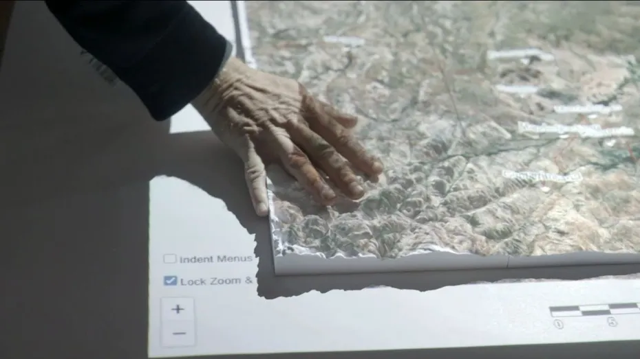
“The model is a 3D printed map the size of a large table, with a projector over the top that brings the 3D map to life,” Mr Williams said.
“You can choose to display different layers so that you can see roads, outstations, elevation, river catchments and floodplains or satellite imagery. But the really cool stuff is the knowledge input by the Elders.
“There are little digital pins on the map of all the places we have made a video, so you can ‘click’ on a pin, and a video pops up of an Elder sitting at that very place and telling a story about it.
“You could click on the place ‘Amala-Arawirr’ and see Samuel Gulwa telling the ancestral story of how a hollow log coffin washed down the Goomadeer River in a flood and came to stop in Junction Bay where it can be seen now as a dangerous sacred site.”
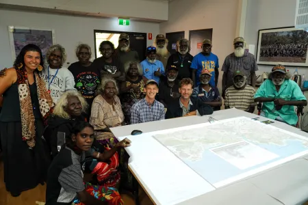
The map, which contains more than three hours of video footage, was delivered to Maningrida College’s Lùrra Language and Culture Centre, who will integrate this resource into the cultural curriculum of the school. Upon its installation, middle and senior classes were invited to interact with guidance from the Elders.
“Anyone who wants to – children, Elders, teachers or community members – can go there and use the map, watch videos, learn the names of places or just look at Country from a different perspective,” Mr Williams said.
“The Lùrra Language and Culture team, made up of Indigenous and non-Indigenous teachers, had loads of thoughts about how they could use the map within their curriculum and add to it over time. It was great to see the ownership taken of this resource.”
Dr Fisher, who has worked extensively to generate 3D simulation tools for rangers, emergency services and schools, said the cooperation showed how combining expertise could produce meaningful results.
“It was a wonderful example of a collaboration where Sam had already done the years of hard work with people on Country but needed a way to make sure all this hard work was brought back to the community and particularly the young people,” Dr Fisher said.
“This project was an excellent example how some appropriate tech can elevate the stories and knowledge. My part was the easy part but the four-way synergy between Sam, the Indigenous knowledge holders and the school came together to make a powerful new way to communicate old stories.
“The tech is simple and robust, combining a 3D-printed tactile landscape with projection. The genius is in the language and knowledge of people.
“So often I work in situations where I know I'll never understand the complex underlying culture and social dynamics but if I can create tools that encourage communication between generations and knowledge systems that's the key. I don't need to understand, I just create a shared space for those that do to share their knowledge and create new understandings through talking together. Collaboration is everything.”
Creation of the 3D map and interface was funded by Maningrida College, the Bawinanga Rangers and the Northern Institute.
Research and fieldwork to film the videos was supported by funding from the Australian Government as part of the Our Marine Parks grant program from Parks Australia.
Related Articles

Australia ranked among world's top countries for quality of life
Australia is one of the world's best countries for overall quality of life, according to an international study into what truly drives well-being.
Read more about Australia ranked among world's top countries for quality of life
CDU invests $2m in First Nations research scholarships
In a push to engage more First Nations students, Charles Darwin University (CDU) is investing up to $2 million in Higher Degree by Research (HDR) scholarship initiatives to strengthen pathways, participation and success for First Nations researchers.
Read more about CDU invests $2m in First Nations research scholarships
Shell yeah: PhD project gives critical insights into vulnerable species
A study into the foraging habits of green turtles in the Northern Territory has used an innovative surveying technique which could become a critical tool in monitoring marine habitats in remote and challenging environments.
Read more about Shell yeah: PhD project gives critical insights into vulnerable species


