Holographic technology used in bushfire management
Technology developed by Charles Darwin University (CDU) Darwin Centre for Bushfires Research is being used for bushfire management.
The technology uses 3D printed landscapes augmented with projected simulations.
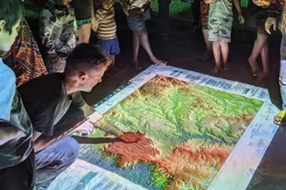
High-resolution 3D printed models are used as terrain surfaces over which projected spatial data, landscape process animations and simulations are displayed.
The use of projection in combination with 3D landscapes adds interactivity and dynamism to spatial information.
Charles Darwin University (CDU) fire information researcher Rohan Fisher from the Northern Australia Fire Information service (NAFI) says the technology uses four-dimensional tactile landscape holographs to inform bushfire prescribed burning.
“The technology and its applications are of particular interest to Traditional Owners and other Indigenous people,” Mr Fisher said.
“The NT’s world-leading carbon abatement methods lead to enhanced biodiversity and significant Indigenous employment in an industry valued at $20 million a year.”
For the 19th consecutive year, NAFI (North Australia and rangelands Fire Information) is providing critical fire information for land managers. NAFI is operated by Charles Darwin University and is the only system for reliably measuring the extent of bushfires across 75% of Australia (Tropical Savannas and Rangelands).
NAFI uses space technology to facilitate on-ground fire management which, over much of Northern Australia, and has supported world-leading fire management outcomes as well as the development of a significant carbon abatement industry predominantly on Indigenous lands.
NAFI helps Indigenous land managers earn carbon credits worth about $20 million a year by providing data to determine the reduction of greenhouse emissions through fire management.
Research has also identified that NAFI saves millions of dollars a year for pastoralists across North Australia through reduced monitoring costs and reduced loss to fodder and infrastructure through bushfires.
There are few, if any, services that CDU provides the broader community that have such deep impacts on the culture of land management, particularly in remote and regional parts of Australia, and has grown, over almost two decades, to inform a whole new industrial sector based on indigenous knowledge and cutting edge science. NAFI represents a globally significant innovation, with considerable interest now being shown for an expansion of the model to Southern Africa and south and central America.
The Federal Government is providing ~$800k in funding to NAFI for this financial year.
Related Articles

CDU student becomes first City of Sydney international student ambassador
For the first time a Charles Darwin University (CDU) student has been accepted into the award-winning City of Sydney International student leadership and ambassador (ISLA) program.
Read more about CDU student becomes first City of Sydney international student ambassador
Shell yeah: PhD project gives critical insights into vulnerable species
A study into the foraging habits of green turtles in the Northern Territory has used an innovative surveying technique which could become a critical tool in monitoring marine habitats in remote and challenging environments.
Read more about Shell yeah: PhD project gives critical insights into vulnerable species
DNA library project marks new chapter for NT biodiversity monitoring
A library of aquatic DNA sounds like it’s been lifted from the pages of a sci-fi novel – but this new and very real database will support future biodiversity monitoring in the Northern Territory.
Read more about DNA library project marks new chapter for NT biodiversity monitoring


