NAFI proves invaluable asset in recent bushfire emergency
Decades worth of fire knowledge, data and experience were put to the test this month with the North Australia & Rangelands Fire Information (NAFI) service receiving an unprecedented number of map requests during the Barkly region bushfires.
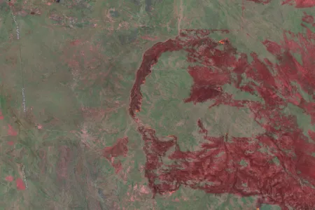
NAFI, a fire information web portal supported through Charles Darwin University’s Darwin Centre for Bushfire Research (DCBR), received about 180,000 map requests a day during the bushfires, which authorities say tore through more than 9,300 square kilometres of land, and threatened Tennant Creek.
NAFI and Charles Darwin University (CDU) staff worked overtime to ensure emergency services and the public could easily access timely and accurate data.
NAFI Service Manager Dr Peter Jacklyn said for the first time in the service’s history due to the significant demand, staff developed a dedicated server for emergency services to ensure reliable performance.
“NAFI provides authorities with data of where the fire is and where it’s recently burned,” Dr Jacklyn said.
“Authorities use this to update themselves on where the fire might be heading and if any burned areas are likely to pull the fire up.”
Dr Jacklyn said NAFI staff knew there would be increased usage this year but not to the extent thus far. Usage of NAFI in September has tripled since the start of the month and is 10 times higher than the same time last year.
CDU spatial software engineer Dr Patrice Weber said by the weekend of the Barkly region bushfires beginning, staff pushed to increase the capabilities of NAFI’s servers due to demand. He said the recent bushfires gave NAFI a glimpse of the kind of demand to expect in the coming months.
“We’re prepared to handle a lot of traffic and to help emergency services specifically,” Dr Weber said.
Dr Weber, who has been with NAFI for four years, said a valuable recent update of the service was hotspot data sourced from the Himawari 8 geostationary satellite, which provides updates on large fires up to two kilometres every 10 minutes. He said this, combined with NAFI’s historic fire data was a significant asset to authorities.
“This combination of fire mapping and detection is really valuable for people on the ground to improvise on the fly,” Dr Weber said.
Dr Jacklyn added: “It’s not as accurate as to where the fire is but what it sacrifices in accuracy of location and ability to pick up small fires, it makes up for with large fires where it can give very frequent updates.”
“If larger fires are picked up by the satellite and are threatening a town, we want to know as frequently as possible where the fire is heading,” Dr Jacklyn said.
This year marked the 20th anniversary of NAFI and since its inception, the service has been become a vital tool used by Traditional Owners, park rangers and pastoralists to manage the land.
CDU’s Northern Institute fire researcher Dr Rohan Fisher said NAFI’s role in fire management and response would only become more critical with the increased risk of fires in the coming months.
“NAFI as a fire watching tool is really accessible, easy to use and allows everyone to keep an eye on what’s happening,” Dr Fisher said.
“It’s important to understand the nature of the continent we live on because is very fire prone.
“NAFI has become deeply embedded into the culture of fire management. As a land management tool, it’s groundbreaking in providing underpinning support for land managers across most of Australia.”
Related Articles

Shell yeah: PhD project gives critical insights into vulnerable species
A study into the foraging habits of green turtles in the Northern Territory has used an innovative surveying technique which could become a critical tool in monitoring marine habitats in remote and challenging environments.
Read more about Shell yeah: PhD project gives critical insights into vulnerable species
Location-specific solutions needed to manage heat in global climate crisis
Place-specific strategies for adapting to increasing temperatures are crucial to keeping remote towns and communities across Northern Australia habitable, according to a recent study on the future impacts of climate change-intensified heat on people in the geographic edges of Australia.
Read more about Location-specific solutions needed to manage heat in global climate crisis
Growing energy efficiency divide making renters sweat
Households are motivated to reduce their energy consumption and help mitigate climate change, but unaffordable technologies and rental restrictions are preventing them from doing so, according to a recent Charles Darwin University study.
Read more about Growing energy efficiency divide making renters sweat


