News article
Darwin region bushfires up three-fold in Sept
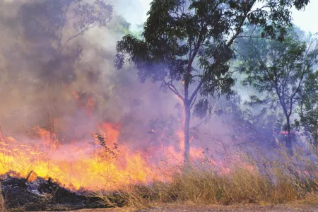
There were record bushfires around Darwin for September, according to data from the North Australia and Rangelands Fire Information (NAFI) website.
NAFI data shows about 141,800 hectares (ha) of land in the North West Top End, covering Darwin and the rural area, was burnt in September. This is more than three times the average area (45,500 ha) damaged by fire activity in September in recent years.
NAFI shows there were more than 160 large fire events in the region for September 2019, but what is striking is the average size of these fires at 8700 ha – around 480 footy fields in size or twice the size of average recent fires in September with particularly large fires in Litchfield National Park and in areas south of Fog Bay and south of Dundee Downs.
NAFI is operated by Charles Darwin University’s Darwin Centre for Bushfire Research and is the only system for reliably measuring the extent of bushfires across Northern Australia.
Using satellite technology, the system provides regularly updated maps of burnt areas, which allows responses to be planned to battle active fires in the short-term and fire control strategies to be devised over the longer term.
Head of fire operations at Bushfires NT, Andrew Turner said the data provided by NAFI gave land managers regularly updated and reliable maps of fire activity and burnt areas near their properties or country.
“This is essential to our management of fire incidents and no other system provides this,” he said.
NAFI data indicates fires this time of year are hotter and more destructive.
“Everyone from our volunteers, block owners, through to pastoralists and rangers know that these are the months when bushfires can really do damage to economic assets because of the intensity of the heat and the potential for windy conditions to drive them,” Mr Turner said.
“This is really where the NAFI comes into its own by providing almost real-time, reliable information on where fires are breaking out or existing ones burning.”
NAFI is also helping Indigenous land managers earn carbon credits worth about $20 million a year by providing data to determine the reduction of greenhouse emissions through fire management.
Research has also identified that NAFI saves millions of dollars a year for pastoralists across North Australia through reduced monitoring costs, and reduced loss to fodder and infrastructure through bushfires.
Chief Executive Officer of the NT Cattlemen’s Association, Ashley Manicaros said NAFI provided pastoralists with an accurate way of locating fires that might be threatening their properties. They use it to track where the fires are going and where they might be pulled up.
“Before NAFI we would be chasing smoke columns in a vehicle and the location of that smoke can be pretty deceptive. NAFI might have started off as a project, but for us it’s now a vital operational service,” Mr Manicaros said.
Hits to the website are up 25% from last year, and it is being used by tens of thousands of people, indicating the important role it plays in bushfire management and the level of fire activity this year.
Related Articles

Australia ranked among world's top countries for quality of life
Australia is one of the world's best countries for overall quality of life, according to an international study into what truly drives well-being.
Read more about Australia ranked among world's top countries for quality of life
CDU invests $2m in First Nations research scholarships
In a push to engage more First Nations students, Charles Darwin University (CDU) is investing up to $2 million in Higher Degree by Research (HDR) scholarship initiatives to strengthen pathways, participation and success for First Nations researchers.
Read more about CDU invests $2m in First Nations research scholarships
CDU student becomes first City of Sydney international student ambassador
For the first time a Charles Darwin University (CDU) student has been accepted into the award-winning City of Sydney International student leadership and ambassador (ISLA) program.
Read more about CDU student becomes first City of Sydney international student ambassador


